
UPDATES: August 2010
UPDATES is a monthly email newsletter on stormwater management, assessment (including monitoring), and maintenance research at St. Anthony Falls Laboratory and the University of Minnesota.
Click HERE to subscribe to UPDATES Newsletter
Or Text SWUPDATES to 22828 to Join. Message and data rates may apply.
For Email Marketing you can trust
August 2010 (vol. 5, issue 3)
Towards a Temperature TMDL for Miller Creek
Contributed by William Herb, Timothy Erickson, Heinz Stefan. University of Minnesota, St. Anthony Falls Lab
Miller Creek is a trout stream which originates near Duluth International Airport, flows through the cities of Hermantown and Duluth, MN and discharges into Lake Superior (Figure 1). Despite a highly urbanized watershed (23% impervious surfaces), Miller Creek has a naturally reproducing Brook Trout fishery. Miller Creek is temperature impaired and was recently put on the list of impaired waters by the Minnesota Pollution Control Agency (MPCA). In support of the temperature TMDL for Miller Creek, the St. Anthony Falls Lab (SAFL) performed a computer modeling study of hydrology, heat loading and stream temperature in Miller Creek.

Figure 1. Map of the Miller Creek watershed, showing Duluth International Airport and extensive wetlands in the upland region and a portion of the City of Duluth in the lower region.
Depending on species and life stage, trout prefer water temperatures in the range of 8-18 °C (46-64 °F), and become stressed in the range of 20 to 25 °C (68 – 77 °F). Most trout streams in Minnesota maintain moderate summer water temperatures due to inputs of cold groundwater. Compared to trout streams in the central and southeast regions of Minnesota, Miller Creek and other North Shore trout streams have relatively low groundwater inputs. Wetlands, lakes, and forested regions provide much of the hydrologic storage for North Shore streams. For Miller Creek, extensive wetlands in the upper portion of the watershed supply most of the hydrologic storage. Historical loss of wetlands in the watershed due to development has impacted both stream temperature and baseflow, with summer baseflow as low as 0.1 cfs.
Temperature impairment of a stream implies that the stream is receiving excessive loading of heat energy for particular climate and flow conditions, due to development activities in a watershed. Land development can increase atmospheric heat inputs (e.g. solar radiation) to a stream via loss of riparian shading and channel widening. Heat inputs to a stream from surface runoff also tend to increase due to increased impervious surface area. Finally, increases in impervious area in a watershed may also impact stream temperature by reducing infiltration, groundwater recharge, and baseflow in a stream. Temperature impairments from stormwater are associated with rainfall events and tend to be shorter in duration than impairments due to atmospheric heating (Figure 2). In Miller Creek, it was found that about 85% of temperature impairments (days with water temperatures exceeding 20 °C) occur on warm, sunny days, with about 15% of temperature impairments caused by stormwater inputs on wet days.

Figure 2. Time series of observed stream temperature in Miller Creek, just downstream of Miller Hill Mall, July 1997.
Computer models can be used to gain a better understanding of stream hydrologic and heat transfer processes. The Miller Creek study included three major computer model components: 1) a watershed-level model for surface runoff and streamflow based on the SWMM package, 2) more detailed models for surface runoff volumes and temperatures based on the SAFL MINUHET model, and 3) several stream temperature models based on the USGS SNTEMP modeling package.
The SNTEMP stream temperature models were used to quantify heat inputs to Miller Creek and the resulting stream temperatures for current riparian shading conditions and for several mitigation scenarios with increased shading. For current conditions, the SNTEMP model matched observed daily average and daily maximum stream temperatures with a root-mean-square-error of 1 to 1.5 ºC (Figure 3). Reductions of up to 2 ºC in maximum daily stream temperature were predicted for increasing shading levels in the impacted middle reaches of Miller Creek.
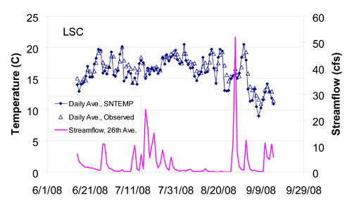
Figure 3. Observed and simulated (SNTEMP) time series of stream temperature in Miller Creek for the period June 15 to September 15, 2008, along with observed streamflow.
A SWMM model for Miller Creek was assembled and calibrated to provide more detailed stream flow inputs to the stream temperature model and to gain a better understanding of hydrologic storage and runoff in the watershed. While observed peak runoff flows were reproduced well by the SWMM model, simulating baseflow conditions in Miller Creek was challenging. By treating upland wetland areas as wide, rough channels, the calibrated SWMM model gave adequate representation baseflow and hydrologic storage for Miller Creek (Figure 4). In addition to providing flow inputs to the stream temperature model, the SWMM model was also used to evaluate several scenarios for mitigating baseflow in Miller Creek by increasing hydrologic storage in wetlands or more conventional detention ponds.

Figure 4. Observed and simulated (SWMM) time series of stream flow in Miller Creek for the period June 1 to October 15, 2008.
The MINUHET surface runoff modeling tool was used to characterize runoff volumes and temperatures for typical residential and commercial watersheds in Miller Creek. Based on land use maps for the watershed, runoff temperatures for these typical developments were then extrapolated to the entire watershed. MINUHET models for wet detention ponds, infiltration basins, and underground stormwater vaults were used to estimate possible reductions in heat loading from surface runoff. Standard wet ponds were found to increase overall heat inputs compared to untreated surface runoff, but reduce peak heat loading rates and maximum stream temperature increases. The use of wet ponds with bottom outlet structures and underground vaults gave some reductions in effluent temperature for smaller rainfall events (< 1 cm), but were of little benefit for larger events. Infiltration practices were found to give the greatest benefit in reducing temperature impacts of runoff, however, widespread implementation of infiltration practices in the Miller Creek watershed is difficult due to near-surface bedrock in many areas.
Overall, the results of the Miller Creek temperature study suggest that the North Shore trout streams are relatively sensitive to land development activities. The loss of upland wetland regions leads to reduced hydrologic storage, higher peak flows, and lower summer baseflow. The lack of strong groundwater inputs to Miller Creek makes stream temperature more sensitive to changes in riparian shading and to variations in air temperature. Long term planning for reducing the impact of existing and future land development in this region will need to consider methods for maintaining hydrologic storage and for maintaining riparian shading. Climate change impacts also need to be considered, with long terms impacts on stream temperature that could exceed those from land development.
Acknowledgements
This study was conducted with support from the Minnesota Pollution Control Agency Urban Stormwater Program, St. Paul, Minnesota, with Bruce Wilson as the project officer. The South St. Louis SWCD provided the streamflow and stream temperature data used in this study. The Minnesota Pollution Control Agency Duluth office also provided data and other technical assistance for this project. The authors are grateful to these organizations for their assistance.
Further Information
General information on Miller Creek may be found at: http://www.duluthstreams.org
General information on Miller Creek may be found at: http://www.duluthstreams.org
Further information on the SAFL Miller Creek project, including PDFs of the project reports listed below, may be found at: http://troutstreamresearch.safl.umn.edu
Questions on the SAFL Miller Creek project may be addressed to:
William Herb, Research Associate
University of Minnesota, St. Anthony Falls Laboratory
2 Third Ave. SE
Minneapolis, MN 55414
References
- Erickson, T.O, W.R. Herb, and H.G. Stefan, 2009. Streamflow Modeling of Miller Creek, Duluth, Minnesota, St. Anthony Falls Laboratory, Project Report No. 536, October 2009, 61 pp.
- Herb, William R. and Heinz G. Stefan, 2009. Analysis of Stream Temperature Data from Miller Creek, Duluth, MN, St. Anthony Falls Laboratory, Project Report No. 529, 52 pp.
- Herb, W.R., B. Janke, O. Mohseni and H.G. Stefan, 2009. MINUHET (Minnesota Urban Heat Export Tool): A software tool for the analysis of stream thermal loading by urban stormwater runoff, St. Anthony Falls Laboratory, Project Report No. 526, 44 pp.
- Herb, William R. and Heinz G. Stefan, 2009. Analysis of Flow Data from Miller Creek, Duluth, MN, St. Anthony Falls Laboratory, Project Report No. 522, 23 pp.
- Herb, W.R. and H.G. Stefan, 2009. Stream temperature modeling of Miller Creek, Duluth, Minnesota, St. Anthony Falls Laboratory Report 535, 78 pp.
- SNTEMP Stream Temperature Model available at:
- http://smig.usgs.gov/cgi-bin/SMIC/model_home_pages/model_home?selection=sntemp
- Storm Water Management Model (SWMM) available at http://www.epa.gov/athens/wwqtsc/html/swmm.html
We want to hear from you!!!
Let us know your thoughts, experiences, and questions by posting a comment. To get you thinking, here are a few questions:
- How should heat loads be allocated in cases where most temperature exceedances occur at low flow?